11 of 220
Previous
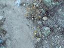
Peters - Hoolie Bacon loop: Note the rock cairn at bottom left on top of a large boulder in the creek bed. The trail crosses and leaves the creek bed for the last time at: N 33.48352 W111.29684 which is shortly past this point.
Next
Location:
• Latitude: N 033° 29' 06.45"
• Longitude: W 111° 17' 49.19"
• Altitude: 962.00m
Date:
11/25/05 7:42:55 AM
W x H:
2560 x 1920
Albums:
Peters - Hoolie Bacon