Official Routes Lines with an asterisk before the trail number are inactive.
Signs can be expected but can not be counted on because of vandalism. Not all of these trails are maintained and you can't count on there being other hikers that day or even within a month. All trails other than Lost Dutchman State park require a map. Some may require either a GPS or extraordinary map skills. All have trailhead parking.
Off-Trail RoutesThere isn't signage, there can be heavy brush, there may or may not be a defined path, there may or may not be cairns. All require a map. Many also require either a GPS or extraordinary map skills. Trailhead parking may consist only of a pull-off for one vehicle--some use official trailheads.
Roads to Trail Heads
GPS Tracks Michale Thorne led a successful effort to collect GPS tracks of all the official Forest Service trails in the Superstitions. You can download the set from: http://web.utah.edu/thorne/gps
A poster and T-shirts are available based on these GPS tracks (with some additions). Trace your hikes with colored markers to impress your friends with your progress in hiking the Superstitions. http://cafepress.com/SuperMtnHikes
Warnings:
Hiking in the desert is inherently dangerous at any time of the year and is very different from hiking in other locales. It's especially dangerous when the high temperature during your hike is above 90°. During late spring and early fall, I start at dawn and finish by noon. I plan hikes so I'm going uphill while it's cool and headed downhill as it warms up.
Don't leave the parking lot unless you have:
A hiking map of the area. Don't depend on USGS Topo maps! They are correct as far as terrain but they show many trails that no longer exist or that have been moved. I have found the Beartooth Publishing waterproof plastic map of the Superstition Wilderness to be the most reliable.
At least the leader of a group should have the Beertooth map. Everyone else, even young children, should have a printed or photocopied map of your route with your route and trail junctions clearly highlighted. I've run into hikers separated from their group and they didn't know the names of the trails they were hiking or which trailhead they had started from. Even if the group tries to stay within sight and wait for everyone to catch up at all junctions, members can get off on the wrong path.
Let others know of your plans and give them contact info for: Superstition Search & Rescue (SSAR) and the Pinal or Maricopa County Sheriffs Offices. The Northern Superstitions (SR-88) are in Maricopa County and the Southern Superstitions (US-60) are in Pinal Country. When hiking alone, stay on trails that will have other hikers--e.g., the main trails out of First Water and Peralta on non-summer weekends. (I don't always follow that rule but I carry a satellite phone.)
Three or four liters of water per person. Even if you don't need it, carrying the extra weight is good exercise.
A first aid kit
Sun protection such as: sun screen, a hat, and appropriate layers of clothing
Suitable footwear
Daytime temperatures in the 80's can drop into the 20's overnight. Almost all of the Superstitions are out of cell phone service. Don't count on trail junctions having signs--many trails aren't signed and vandals steal those that have been posted.
Your hiking safety depends on your preparation, experience, judgement, fitness, desert acclimation, equipment, and luck. A missed turn, a twisted ankle, a lost or leaking water bottle can turn a pleasant hike into a nightmare. On many Superstition Wilderness hikes, it's possible to trip or fall and suffer serious injury or death.
Staying on trail is a skill that is developed by hiking in the desert. It's possible to get lost even on the popular trails out of First Water or Peralta. It's easy if you don't have a good map. Trails are generally more difficult to follow in the fall. They've had little traffic over the summer but the vegetation has been growing.
There are no warranties, either expressed or implied, that the information on this Web site is accurate, reliable, or represents current conditions. Your use of this site is an acknowledgement of your sole responsibility for your safety.
Current Information Trail and access conditions are constantly changing and may be very different than described on this site. Floods can wipe out portions of a trail. Heavy snow can fell trees across the trail and slow down travel for years afterwards. Many official Forest Service trails are not maintained and see only a few visitors a year.
The Forest Service and others may close access roads which can add additional miles to a hike. On the other hand a road listed as High Clearance (HC) and Four-Wheel Drive (4WD) may have been recently graded and be a much easier drive for a year or so. Unbridged crossings can be closed by fast running water for hours or days and may have exposed rocks or soft sand after a rain.
The best source of current information is Hike Arizona (http://HikeArizona.com). Check recent trip reports and/or ask about your plans on the forum.
Superstition Wilderness Trails East: Hikes, Horse Rides, and History
from Carlson and Stewart covering the Eastern Superstitions
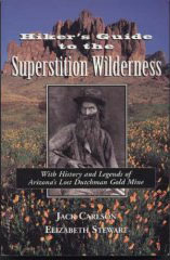
Hiker's Guide to the Superstition Wilderness
This has been the bible on hiking the Western Superstitions since 1995.
It's not suitable as the sole source of current info but it has a wealth of historical information that will make your hike a lot more enjoyable.
I have two copies: one of which I tear apart and take the pages relevant to a hike along with me.
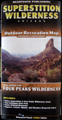
Beartooth Publishing 's waterproof map of the Superstition Wilderness
Only idiots hike the Superstition Mountain Wilderness without this map in their pack. You need to carry this map for your personal safety.
This is the only map that has the correct routes for the trails. UGS Topo maps (and GPS maps created from them) are based on decades old data--many trails shown on them are no longer there or have been rerouted. UGS maps are still useful since they have more detailed terrain data.
I've hiked all the official Forest Service trails in the Superstitions and have never found an error in this map. Make sure you buy at least the 2008 (Third) Edition. It has updated info, especially on access roads. Some trails have been dropped from this edition that the Forest Service no longer maintains such as the: 195 Rock Creek Trail.